Daily Maps Monday February 10th, 2025

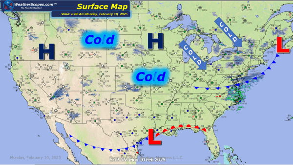
Some cold arctic air coming down through the Plains and Great Lakes this morning and today. Some light snow showers across the Plains and Dakota's with accumulations of a coating to 2''. Some Lake Effect snow in parts of the Great Lakes and Northeast today. Accumulations look to be a coating to 2'' with the... Continue Reading →

Weekly Highlights February 9th to 15th

This week will be one for all the snow lovers. We will see 3 snow-storms affect most of the US. Tuesday into Wednesday, Friday into Saturday and Saturday into next Sunday will be the days where we will see rain, sleet, ice, snow, a chance at severe weather and some localized flooding. A busy week for... Continue Reading →

Daily Maps Sunday February 9th, 2025

Some lingering snow in the Northeast from the system that came through yesterday, and some light accumulating snow throughout the Great Lakes. The Great Lakes will see a dusting today while this week could bring some significant snow. Accumulations today for the Northeast look to be a coating and around 3-6'' total for the Boston... Continue Reading →

Daily Maps Saturday February 8th, 2025

Another day, another storm dropping snow in the Upper Great Lakes. That system will make its way towards the Northeast later tonight and into Sunday. Accumulations for the Great Lakes look to be 4-6'' to the north and further south will see a coating to 3''. That system will produce similar accumulations in the Northeast.... Continue Reading →

Website Powered by WordPress.com.

Up ↑