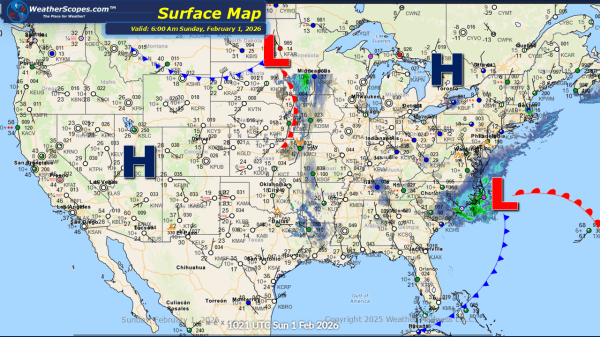
This morning, a clipper system is moving through the Plains and is expected to track into the Upper Great Lakes later tonight into tomorrow. Snow accumulations look to be around a coating up to 3 inches in some areas. The remnants of the system that produced snow across the Carolinas is moving offshore but continues... Continue Reading →
Daily Maps Friday January 30th, 2026
This morning, light snow is occurring across the Plains, with accumulations ranging from a light coating up to 1 inch. Lake-effect snow will once again impact the Great Lakes region today, with the heaviest accumulations expected in the Upper Peninsula of Michigan, the Buffalo area, and southeastern Wisconsin into the Chicago metro area. Most locations... Continue Reading →
Daily Maps Thursday January 29th, 2026
This morning, a clipper system is moving through the Plains, producing a light coating of snow. Lake-effect snow continues to impact the Great Lakes region today, with accumulations of 4 inches or more in areas closest to the lakes. Arctic cold remains entrenched across the Plains, Great Lakes, and Northeast, with temperatures well below zero... Continue Reading →
Daily Maps Wednesday January 28th, 2026
This morning, a clipper system is moving through the Great Lakes into the Northeast, bringing continued lake-effect snow to the region. Snow accumulations are expected to be light for most areas, generally a coating, while portions of the Upper Peninsula and western Michigan could receive more than 3 inches. The Buffalo and Syracuse areas may... Continue Reading →
