Daily Maps Thursday December 4th, 2025

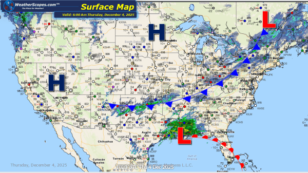
Today showers and thunderstorms will go through areas in Texas and move to the east into the Southeast. These storms don't look to be severe. Some lake effect snow will move through the Great Lakes into the Northeast, with accumulations of a dusting to 2''. New Mexico into the Southern portions of Oklahoma and the... Continue Reading →

Daily Maps Wednesday December 3rd, 2025

This morning we already seeing the Denver metro area seeing snow. Accumulations look to be around 2-4'' with areas further south seeing 5-7''. The Rockies will also see some snow today as well. In the Great Lakes and part of the Interior portion of the Northeast, a clipper will come through today bringing a dusting... Continue Reading →

Daily Maps Tuesday December 2nd, 2025

This morning we are already seeing a mess of a system go through the Northeast, with snow mixed with some sleet and freezing rain. Areas north of the I-95 corridor are seeing mostly snow mixed with some rain, while areas south are seeing rain. Most areas will see accumulations of 1-4'' with areas in NE... Continue Reading →

Daily Maps Monday December 1st, 2025

Today we will see some snow across the Plains into the Midwest and Great Lakes. Accumulations look to be 1-4’’. Tonight into tomorrow snow will move into the Northeast and some mixed precipitation to areas south of the snow, which could make for some dangerous conditions. The I-95 corridor looks to be where to the... Continue Reading →

Website Powered by WordPress.com.

Up ↑