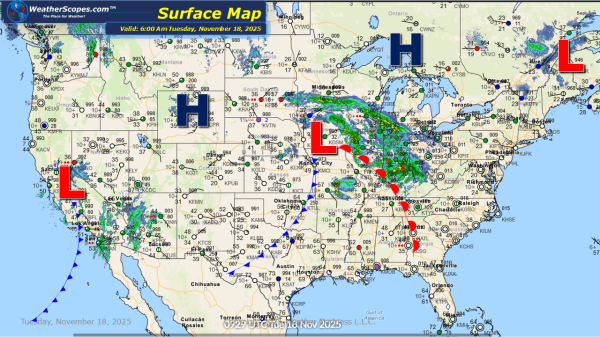
This morning we are already seeing showers and thunderstorms across the Midwest into the Ohio Valley. Some of these storms could bring some gusty conditions around Southern Illinois and the surrounding area. To the north of this system some light accumulating snow will fall. While a few days ago this system looked more impressive, areas... Continue Reading →
Weekly Highlights November 17th to 22nd
This week, a quick-moving Clipper system will slide through the Northeast from Monday into Tuesday, bringing a light round of snow to the region. Most locations can expect anywhere from a coating to around 2–3 inches, though the fast nature of the system will keep totals modest. Another similar Clipper may follow on Saturday, potentially... Continue Reading →
Daily Maps Sunday November 16th, 2025
Today Southern California into the Southwest will continue to deal with some heavy rain in the area. Localized flooding will still be an issue to watch into tomorrow. Today and into tomorrow portions of the Northeast will see some snow showers come into the area, along with the possibility of some ice as well. Snow... Continue Reading →
Daily Maps Saturday November 15th, 2025
Today Southern California will continue to see showers across the area, and the chance for some localized flooding. The Ohio Valley into parts of the Northeast could see some gusty storms later today with the chance for some hail associated with these storms. In areas along interior portion of the Northeast, more specifically upstate NY,... Continue Reading →
