Daily Maps Saturday September 6th, 2025

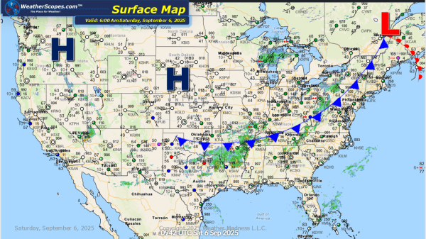
This morning we are already seeing showers and thunderstorms in the Southeast and some showers across parts of the Northeast. Later today storms will develop from Maine to the Carolinas and some of those storms could be severe. Gusty conditions, hail, and heavy rains at times will all be in play with these storms. Localized... Continue Reading →

Daily Maps Friday September 5th, 2025

Today some severe storms look to develop in the Ohio and Tennessee Valley. That area could see some gusty conditions and hail. The Southwest look to see some downpours today which could lead to some localized flooding. The Pacific NW wildfires still burning and mixed with the Western Canada fires to create some poor air... Continue Reading →

Daily Maps Thursday September 4th, 2025

This morning we are already seeing showers and thunderstorms move across the Ohio and Tennessee Valley's into the Northeast. Some of those storms could become severe and provide some gusty conditions. Those storms will move to the east throughout the day and into the overnight hours. The Upper Great Lakes are seeing some showers and... Continue Reading →

Daily Maps Wednesday September 3rd, 2025

This morning we are already seeing some showers and thunderstorms make their way across the Great Lakes and Plains. That will continue today as more storms develop later today that could become severe out in the Plains. The Southwest will see some locally heavy rain, which could lead to some localized flooding. The NE portion... Continue Reading →

Website Powered by WordPress.com.

Up ↑