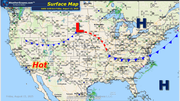
Today we will see some showers and thunderstorms develop in the High Plains into the Upper Great Lakes, bringing some severe weather and downpours. The Four Corners States will see more rain from the monsoonal flow and could see some flash flooding. Wildfire smoke continues to build in the western part of the US from... Continue Reading →
Daily Maps Thursday August 14th, 2025
Today showers and thunderstorms will develop in the Mid-Atlantic into the Southeast, with some heavy rains at times. Some severe storms will develop in the High Plains and into the Upper Great Lakes. Some locally heavy rains with those storms as well. The west continues to be hot and dry, increasing the fire danger and... Continue Reading →
Daily Maps Wednesday August 13th, 2025
Today we will see storms in the Northeast down through the Mid-Atlantic States and into the Southeast. These storms will bring gusty conditions, heavy downpours, and some could become severe. Severe storms will develop out across The Plains today and later tonight. Some of those storms in the Plains could produce some hail and gusty... Continue Reading →
Daily Maps Tuesday August 12th, 2025
Today some showers and thunderstorms in the Midwest and into the Great Lakes. These storms will bring some gusty conditions and heavy rains. Some localized flooding could be an issue to watch for. The heat and humidity returns to the East today, and continues in the West. The wildfires continue to burn in the West... Continue Reading →
