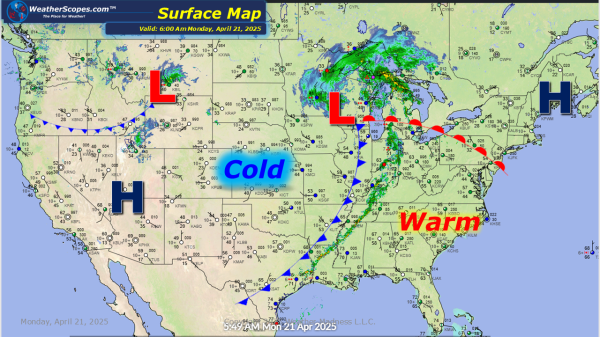
Some cooler weather in the Plains, Great Lakes, and into the Northeast today. With the cooler temps Northern Wisconsin and Northern Minnesota will see snow showers today. Accumulations look to be a coating to 1''. Windy conditions today in the Great Lakes into the Ohio Valley with gusts of 30-35mph. Rain and thunderstorms moving into... Continue Reading →
Weekly Highlights April 20th to 26th
This week to start off the holiday, we will still be dealing with severe weather multiple times this week. From the Plains to the Midwest to the Ohio Valley and into parts of the Northeast and Mid-Atlantic states. Over the course of the week, we will see storms develop multiple times over the course of... Continue Reading →
Daily Maps Saturday April 19th, 2025
More severe weather today across the Ohio and Mississippi Valley's, as you can see from the line of storms. Dew point temps will be in the 60's across the Mississippi Valley and the South which will likely be the areas some tornadoes develop today. Hail and gusty conditions will be associated with these storms throughout... Continue Reading →
Daily Maps Friday April 18th, 2025
A busy day today with weather. The Rockies and the Denver metro area will see some accumulating snow today through tomorrow. The Rockies will see over 4''+ while Denver will see 1-4'' and areas further south of Denver could see higher totals. Severe weather has already broken out across Wisconsin this morning. Those storms will... Continue Reading →
