Weekly Highlights February 16th to 22nd

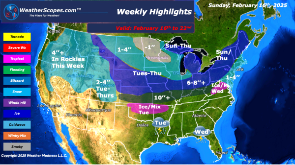
This week to start the Northeast will see some significant snow. Areas of NY to Vermont, New Hampshire, and Maine could see snow totals over 12’’ on Sunday, while areas south will see 1-4’’. On the backend areas of the Great Lakes will seesone snow as well. Accumulations 1-4’’. Along with the snow the Northeast will also deal with some ice and mixed precip associated with the... Continue Reading →

Daily Maps Sunday February 16th, 2025

For much of the Northeast and Great Lakes today snow, ice, and wind will bring a blustery start to the week. Ice this morning through parts of central PA to the Boston area. The further interior areas of the NE especially, upstate NY, Vermont, NH, and Maine will see blizzard like conditions and over 12''... Continue Reading →

Daily Maps Saturday February 15th, 2025

Snow continuing today in the Midwest, Great Lakes and into the Northeast. Accumulations look to be a coating to 4''. Higher amounts in the Northeast, Michigan, and parts of Nebraska. Along with the snow moving through, some mixed precipitation and ice will accompany it in areas of the Ohio Valley. Later today some strong storms... Continue Reading →

Daily Maps Thursday February 13th, 2025

Snow continues in the Northeast today from the storm yesterday. Parts of update NY, Vermont, NH, and Maine could see snow accumulations of 8''+. Areas south could see a coating of snow and some rain as well. The Boston area could see some freezing rain. Some lake effect snow in the Great Lakes with some... Continue Reading →

Website Powered by WordPress.com.

Up ↑