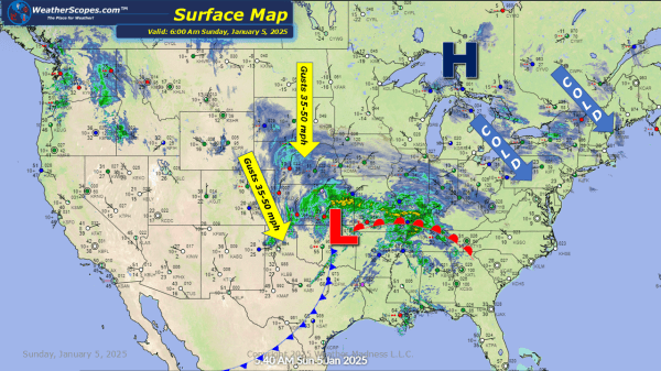
Today the first big snowstorm of the season will hit the Plains, Midwest, Tennessee Valley and into the Northeast. Heavy winds are driving this storm to the East, and bringing ice and heavy snow to some areas. Snow rates will be 1-3'' an hr and some areas in the middle of this storm could see... Continue Reading →
Daily Maps Saturday January 4th, 2025
Big winter storm coming into the Plains today and tonight that will move through the Midwest, and into the Northeast over the next few days. Snow accumulations ranging from a dusting to a few inches to some 20'' possible. Ice will also be associated with this storm and will make for some dangerous travel in... Continue Reading →
Daily Maps Friday January 3rd, 2025
Today some snow in the high Plains which will produce a coating of snow - 1''. That system will continue to the SE today and meet the system that will produce some significant snow and ice this weekend. Snow in the Ohio Valley that will make its way to the coast. Accumulations look to be... Continue Reading →
Daily Maps Thursday January 2nd, 2025
A clipper coming through Iowa into the Midwest and Ohio Valley today into tonight. Snow accumulations look to be around 1-3''. The Northeast is still dealing with some lake effect snow. Erie has seen over 6''+ and will continue to see more today, as well as the Northeast. Accumulations look to be around 1-3''. The... Continue Reading →
