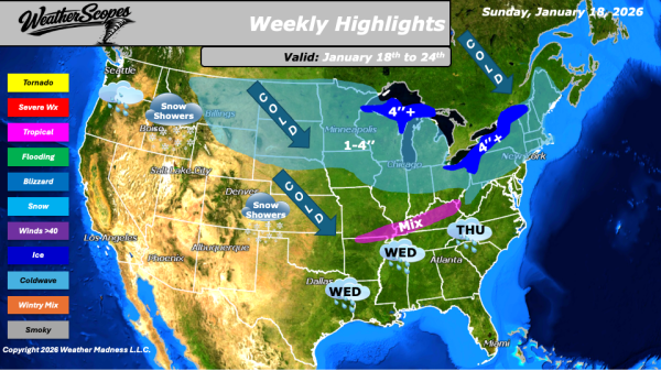
As we move through the week, a persistent winter pattern will dominate much of the United States, bringing widespread cold, periodic snow, and several rounds of unsettled weather. The coldest conditions will be felt across the Northern Plains and Great Lakes, where temperatures will struggle to rise out of the single digits during the day.... Continue Reading →
Daily Maps Sunday January 18th, 2026
This morning, we are seeing rain coming up the Southeast coast. Snow showers in southern Georgia as well with some light accumulating snow. A coating to 1'' for areas in southern Georgia and Alabama. The rain will continue up the coast bringing some decent rains and bringing snow to the coastal areas of the Northeast.... Continue Reading →
Daily Maps Sunday January 17th, 2026
This morning, we are seeing some snow showers across the Great Lakes into parts of the Midwest. Accumulations look to be light with a coating to 2''. The UP and western portions of Michigan could see some higher amounts with 4''+ possible. Rain in the Southeast out ahead of a cold front that will impact... Continue Reading →
Daily Maps Thursday January 15th, 2026
This morning, we are seeing snow come through the Great Lakes, Northeast, and into the Appalachians. This system will continue to make its way to the east throughout the day. Accumulations look to be a coating to 4'', with areas further interior in the Northeast seeing 4''+. Later tonight another system will come through the... Continue Reading →
