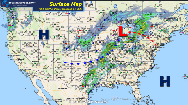
This morning we are seeing showers and thunderstorms in the Midwest and moving into the Ohio Valley, after multiple reports of tornadoes yesterday across the area. This system will continue to bring unsettled conditions through the day. From the Ohio Valley into parts of Texas and the Lower Mississippi Valley, we can expect the same... Continue Reading →
Daily Maps Monday March 9th, 2026
Today, across the Lower Mississippi Valley, scattered showers and thunderstorms are expected to develop throughout the day. While most storms will remain typical for the region this time of year, a few could become severe, bringing the potential for stronger winds and heavier rainfall in localized areas. In the Pacific Northwest, unsettled weather will continue... Continue Reading →
Weekly Highlights March 8th to 14th
The week begins with unsettled conditions across the Southeast on Sunday, where showers and thunderstorms are expected to develop and move through the region, and again on Monday in the Lower Mississippi Valley. Attention then turns to a more significant storm system developing Tuesday into Wednesday. Severe weather is expected to return from the Upper... Continue Reading →
Daily Maps Saturday March 7th, 2026
This morning, snow and mixed precipitation are moving through the Upper Great Lakes this morning, bringing light accumulations generally ranging from a coating up to around 1 inch. While the snowfall is relatively minor, it marks a noticeable shift in conditions across the region as a cold front begins to move through, leading to cooler... Continue Reading →
