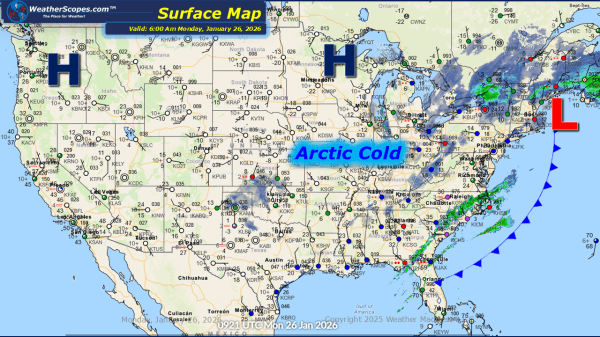
This morning, we are seeing snow across the Great Lakes and into the Northeast, extending into parts of the Virginias. Accumulations look to be around a coating, with heavier snow in the interior portions of the Northeast where 1-4'' could fall. Breezy conditions are expected for much of the eastern portion of the US today.... Continue Reading →
Daily Maps Friday January 9th, 2026
This morning, we are off to a busy start. Snow is impacting Colorado into New Mexico. Accumulations look to be around 1-4'', with some areas along the CO/NM border seeing 4''+. That system will move through the Plains into the Great Lakes tomorrow, bringing some light accumulating snow through the Plains. Showers and thunderstorms are... Continue Reading →
Daily Maps Thursday January 8th, 2026
This morning, we are already seeing showers and thunderstorms move across the Plains into Oklahoma and Texas. This system will move through the Midwest and Great Lakes throughout the day. Some severe weather is possible with this system as gusty storms and heavy downpours could become an issue. A tornado can't be ruled out with... Continue Reading →
Daily Maps Wednesday January 7th, 2026
This morning, we are seeing some mixed precipitation in the Northeast with rain/snow and freezing rain. Snow today out west in The Rockies. Some showers in the Southwest today. Mild temperatures continue for much of the Central US today, which has been nice to be above freezing. Looking ahead some stormy weather over the next... Continue Reading →
