Weekly Highlights March 2nd to 7th

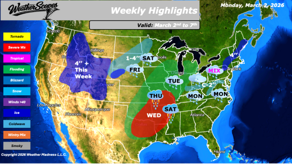
This week will feature an active weather pattern across much of the country, with a mix of rain, snow, and thunderstorms impacting several regions. Monday will start the week with a rain and snow mix across the Tennessee Valley, moving into the Mid-Atlantic states. Accumulations are generally expected to range from a light coating up to 1... Continue Reading →

Daily Maps Monday March 2nd, 2026

This morning, we are seeing a system come through the Tennessee Valley into parts of the Southeast and Mid-Atlantic states. Areas to the north will see some mixed precipitation and some snow, while areas south will see rain. Snow accumulations look to be light, and with milder temperatures in place, the snow will not accumulate... Continue Reading →

Daily Maps Friday February 27th, 2026

This morning, we are seeing some rain showers come through the Carolinas and stretching back along the Gulf Coast. A notable warm-up is underway. Some milder weather is settling in today across much of the Plains into the Midwest and Northeast. Portions of the Plains will see temperatures climb into the 70s, an impressive mark... Continue Reading →

Website Powered by WordPress.com.

Up ↑