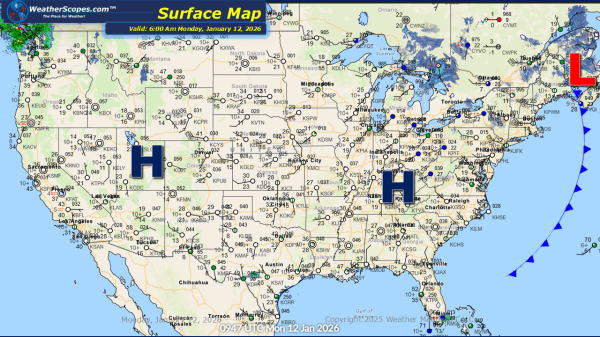
This morning, we are seeing some showers out in the Pacific NW, and a clipper coming through Canada that will bring some snow to the interior portions of the Northeast later today. Accumulations look to be around a coating to 3''. Colder weather settling in the eastern portion of the US, as not much will... Continue Reading →
Weekly Highlights January 11th to 17th
This week’s weather pattern remains active across much of the country, with winter firmly holding on in several regions. A series of fast-moving clipper systems will track through the Great Lakes and into the Northeast, bringing multiple chances for light to moderate snow. These systems may not be major storms on their own, but together... Continue Reading →
Daily Maps Sunday January 11th, 2026
This morning, we are seeing snow across the Great Lakes and into the Northeast, extending into parts of the Virginias. Accumulations look to be around a coating, with heavier snow in the interior portions of the Northeast where 1-4'' could fall. Breezy conditions are expected for much of the eastern portion of the US today.... Continue Reading →
Daily Maps Friday January 9th, 2026
This morning, we are off to a busy start. Snow is impacting Colorado into New Mexico. Accumulations look to be around 1-4'', with some areas along the CO/NM border seeing 4''+. That system will move through the Plains into the Great Lakes tomorrow, bringing some light accumulating snow through the Plains. Showers and thunderstorms are... Continue Reading →
