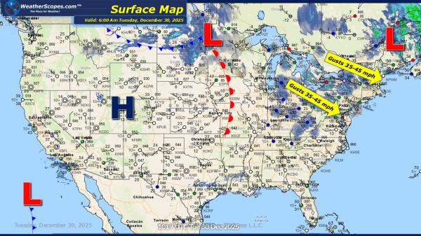
This New Year's Eve morning, we are still seeing some lake-effect snows in the Northeast, and we will see a clipper come through the Great Lakes and Ohio Valley later today. The clipper looks to bring a coating to 2'' of accumulating snow, while the lake-effect snows continue to build up snow totals in the... Continue Reading →
Daily Maps Tuesday December 30th, 2025
Today the Northeast and Ohio Valley will see some lake-effect snows, and another clipper will come through the Great Lakes today bringing more accumulating snow. The clipper coming through looks to bring a coating to 2'' to the area. Areas along the Great Lakes will continue to see their snow totals increase for the week,... Continue Reading →
Weekly Highlights December 29th to January 3rd
This week’s weather pattern features a broad mix of winter and active conditions across much of the US. A series of lake-effect and clipper systems will bring periodic snow to the Great Lakes and the Northeast throughout the week. These fast-moving systems are expected to produce light to locally moderate snowfall, particularly downwind of the... Continue Reading →
Daily Maps Monday December 29th, 2025
This morning, we are seeing snow, rain, and gusty conditions across the Great Lakes into the Northeast. Out ahead of a cold front that came through the Great Lakes and Midwest, some rain in the Northeast and Mid-Atlantic states, extending into the Southeast. That cold front extends from Canada down into the Southeast. In the... Continue Reading →
