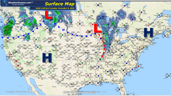
This morning we are seeing another clipper come through the Upper Great Lakes as it moves into the Northeast later today. Tonight yet another clipper will come through the Great Lakes and Northeast into tomorrow. Clipper snow will be the theme for the next 10 days or so with almost daily chances for snow to... Continue Reading →
Daily Maps Monday December 8th, 2025
This morning we are already seeing some mixed precipitation across Tennessee, Kentucky, the Virginia's and into North Carolina. The Virginia's, Kentucky, and Tennessee look to see some wet accumulating snow 1-4'', while areas along the Virginia/North Carolina border could see some snow and rain. Out in the Pac NW still dealing with some heavy rains... Continue Reading →
Daily Maps Sunday December 7th, 2025
A fast-moving Clipper swept across the Plains and Great Lakes overnight and into the early morning hours, dropping a quick 2–4 inches of snow for many locations. This system continues to move into the Northeast later today before exiting by tonight. While accumulations there will be lighter, slick travel is still possible during the afternoon... Continue Reading →
Weekly Highlights December 7th to 13th
This week’s weather will be shaped by a steady parade of clipper systems dropping out of Canada and sweeping through the Plains, Midwest, Great Lakes, and eventually the Northeast. The first clipper arrives Sunday, spreading snow across the Plains and into the Great Lakes to start the week. This sets the pattern going forward, with... Continue Reading →
