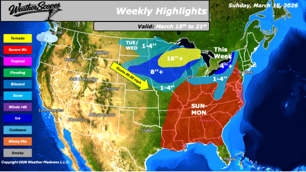
Daily Maps Friday February 27th, 2026

This morning, we are seeing some rain showers come through the Carolinas and stretching back along the Gulf Coast. A notable warm-up is underway. Some milder weather is settling in today across much of the Plains into the Midwest and Northeast. Portions of the Plains will see temperatures climb into the 70s, an impressive mark... Continue Reading →

Daily Maps Thursday February 26th, 2026

This morning, we are seeing some showers come through the Southeast into the Mid-Atlantic states. Just to the north in the Ohio Valley there is some light snow falling. Accumulations will be light with a coating at most, primarily on grassy and elevated surfaces. Additional light snow is moving through the Upper Great Lakes, where... Continue Reading →

Daily Maps Wednesday February 25th, 2026

This morning, showers and gusty conditions are moving through the West, while snow continues in the higher elevations of the Rockies, creating hazardous travel conditions in mountain passes and surrounding areas. Wind gusts will be in the 40-50s. Farther east, a clipper is tracking through the Great Lakes and into parts of the Northeast. This... Continue Reading →

Daily Maps Tuesday February 24th, 2026

This morning, we are seeing some rain continue to impact the Pacific Northwest and into Northern California, where the area could see some localized flooding from the rain that has fallen over the last few days. Saturated ground conditions combined with additional precipitation may lead to ponding on roadways, rises on small streams, and minor... Continue Reading →

Website Powered by WordPress.com.

Up ↑