Weekly Highlights June 8th to 14th

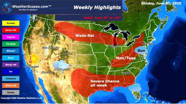
This week we will see a threat of severe weather daily in certain areas of the US, and we continue to deal with the smoke and haze from the Canadian wildfires. To start the week, we will see severe storms in the Mid-Atlantic states down to Florida. Heavy rains and winds will be the major threats, as well as... Continue Reading →

Daily Maps Sunday June 8th, 2025

Today storms will develop in the Mid-Atlantic States down to the Carolinas and parts of Florida. The Southern Plains into Texas will see storms develop later tonight and into tomorrow. Gusty winds, hail, and tornadoes will be in the play with these storms across Texas and Oklahoma. Localized flooding out across Oklahoma and Texas will... Continue Reading →

Daily Maps Thursday June 5th, 2025

Today a low-pressure system making its way through the Carolinas producing showers and thunderstorms. Some localized flooding will be an issue. Storms developing in western to central Texas later today. Gusty conditions and hail possible with those storms. A tornado not out of the question with dew points in the 60's and low 70's. More... Continue Reading →

Daily Maps Wednesday June 4th, 2025

Showers and thunderstorms this morning out across the Great Lakes down into the Upper Mississippi Valley. Those showers will continue for most of the day. Some storms develop later in the day across Western Texas. Some of those storms could be severe. The four corners states continue to see some showers today, and could see... Continue Reading →

Website Powered by WordPress.com.

Up ↑