Daily Maps Thursday June 19th, 2025

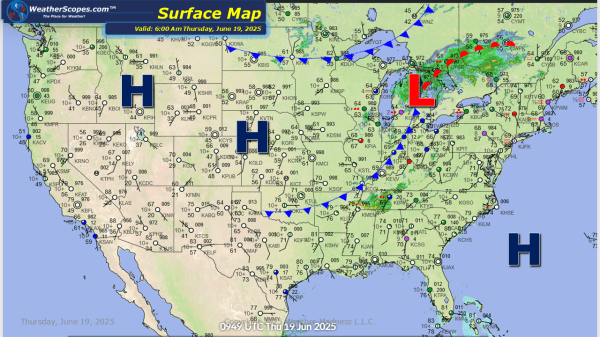
This morning some showers and thunderstorms in the Upper Great Lakes, and in the Southeast. Later today some severe storms will develop out ahead of a cold front in parts of the Northeast and Mid-Atlantic States. These storms will bring heavy rains, windy, hail, and a possible tornado. Localized flooding will also be a concern... Continue Reading →

Daily Maps Wednesday June 18th, 2025

Today more severe storms will develop out across the Midwest into the Tennessee and Mississippi Valleys's. These storms will bring heavy rains, hail, gusty conditions, and tornadoes. With the heavy rains in the Midwest, expect to see some flooding potential. These storms will be ongoing for most of the day and into the evening. The... Continue Reading →

Daily Maps Tuesday June 17th, 2025

Showers and thunderstorms today across the Plains today bringing gusty winds, hail, and a possible tornado. Some heavy rainfall across the Plains could result in some flash flooding in certain areas. More showers and thunderstorms in the Ohio and Tennessee Valley's today as well as the Southeast. Some areas in the Ohio and Tennessee Valley's... Continue Reading →

Daily Maps Monday June 16th, 2025

Today showers and thunderstorms will develop out across the Plains into the Upper Great Lakes which will produce some severe weather. High dew points in the Northern Plains and into Parts of MN and WI today could produce some tornadoes. More showers in the Ohio Valley into the Appalachians where they could see some localized... Continue Reading →

Website Powered by WordPress.com.

Up ↑