Daily Maps Saturday February 7th, 2026

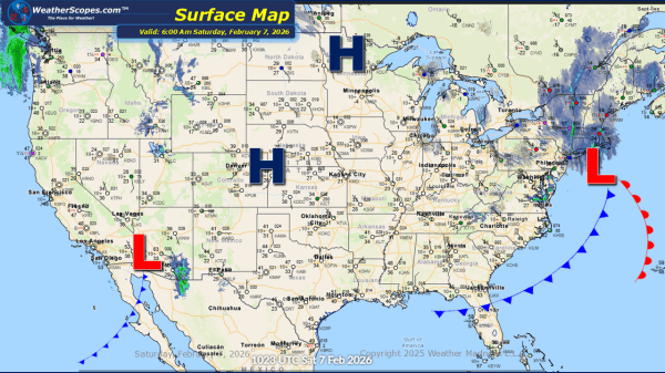
This morning, we are seeing snow across the New England area and portions of the Northeast, from a clipper coming down. Accumulations look to be a coating in most areas with 1-4'' of snow in the New England area. Gusty conditions along with some arctic cold will impact the Northeast today, bringing some dangerous wind... Continue Reading →

Daily Maps Friday February 6th, 2026

This morning, we are seeing another clipper come through the Great Lakes into the Northeast and Ohio Valley. General accumulations range from a coating to 4'', with areas in Western Michigan and into the Appalachians that could see heavier totals. This weekend in the Northeast some dangerous cold and gusty conditions will dig into the... Continue Reading →

Daily Maps Thursday February 5th, 2026

This morning, we are seeing our next clipper come through the Great Lakes. Accumulations look to be light with a coating to the area. Later tonight and into tomorrow another clipper will come through the Great Lakes, the Northeast and into parts of the Mid-Atlantic States. Accumulations tomorrow look to be a coating to 4'',... Continue Reading →

Daily Maps Wednesday February 4th, 2026

This morning, scattered showers are developing ahead of a cold front across the Southeast, bringing cooler conditions to the region by Thursday. Light snow showers are expected in the Great Lakes and Northeast, with minor accumulations possible, generally a light coating. Later tonight, rain will transition to snow extending from eastern Tennessee/Kentucky, into North Carolina,... Continue Reading →

Website Powered by WordPress.com.

Up ↑