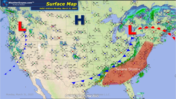
Today more severe weather will break out in the Southeast and impact the Mid-Atlantic states today. These storms will bring hail and gusty storms. A tornado is not out of the question. Storms will also impact parts of the Northeast today from, Philadelphia to NYC up into Rhode Island. Almost an 1'' of rain is... Continue Reading →
Weekly Highlights March 30th to April 5th
This week looks to be a busy week with severe weather on multiple days and snow and ice. To start the week of on Sunday we will see some severe weather break out in the Mississippi Valley up into parts of the Midwest. With these storms windy conditions and hail are possible as well as... Continue Reading →
Daily Maps Sunday March 30th, 2025
Today snow and ice will impact parts of the Northeast from NY to Maine. Accumulations look to be around 1'' for snow and .10'' of ice. That system extends all the way back to the Upper Great Lakes for parts of WI, MN, and the UP of Michigan that will see snow and ice. Accumulations... Continue Reading →
Daily Maps Saturday March 29th, 2025
Today we have snow and some mixed precipitation coming through parts of the Northeast. Parts of Upstate NY, Vermont, New Hampshire, and Maine could see over 4'' of snow and some ice. We have some thunderstorms moving through the Plains into the Midwest and Ohio Valley today, as well as the Mississippi Valley, today and... Continue Reading →
