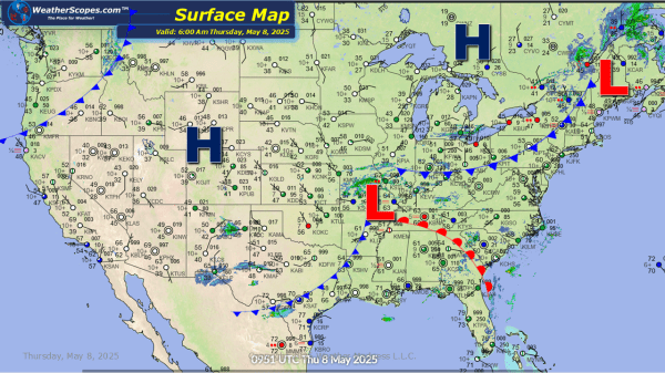
Today showers and thunderstorms across the Tennessee Valley into parts of the Northeast, as well as southern Texas. Across the Tennessee Valley damaging winds and hail will be the biggest threat. Localized flooding will also be something to watch as these areas have seen a decent amount of rain over the last few days. Some... Continue Reading →
Daily Maps Tuesday May 6th, 2025
Already this morning we are seeing storms out across the Southern Plains into Texas, and across the Ohio Valley into parts of the Great Lakes. Storms will continue in the Southern Plains and Texas throughout the day and eventually move into the lower Mississippi Valley and become severe. Hail, damaging wind, and tornadoes are possible... Continue Reading →
Daily Maps Monday May 5th, 2025
This morning showers continue in the Ohio and Tennessee Valley with some gusty storms expected later today in the Northeast and Mid-Atlantic states. Showers across Montana this morning and some thunderstorms already developing across the Texas panhandle. Those storms will continue to intensify throughout the day across Texas and be severe. Gusty conditions and hail... Continue Reading →
Weekly Highlights May 4th to 10th
This week we are still in an omega blocking pattern that resembles the Greek letter, where two closed off lows separate from the jet-stream. Two low-pressure troughs of cool unsettled weather upstream (West) and downstream (East) and warm dry air in the middle (The Plains). We will be dealing with this pattern until mid-week, where the East and West will see... Continue Reading →
