Weekly Highlights January 19th to 25th

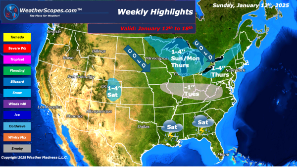
This week we start with an arctic winter storm making its way through the Great Lakes and Northeast today into tomorrow. The storm will bring very cold weather, wind, along with dangerous wind chills that are below zero through mid-week. Snow accumulations look to be around 1-4’’ with 4’’ + along the I-95 corridor. Blizzard... Continue Reading →

Weekly Highlights January 12th to 18th

This week we will see a few clippers come through and bring some cold and windy weather with it. A pretty quiet week on the horizon before the next few have the potential to produce some snowstorms. To start on Sunday the Northern Great Lakes will see a clipper produce 1-4’’ of snow throughout the... Continue Reading →

Weekly Highlights January 5th to 11th

This week a major snowstorm is well under way. From KC to DC and in between, should see significant amounts of snow and blizzard like conditions. The snowstorm will make its way through the area on Sunday and Monday. Snow accumulations range from a dusting to 16’’ + from areas in Nebraska through the Ohio/Tennessee Valley and into the Nations Capital. The DC area could see over... Continue Reading →

Weekly Highlights December 29th to January 4th

This week we will start with some severe weather and the chance for tornadoes. Sunday, storms develop in the Southeast and make their way towards the Mid-Atlantic States into Florida. Those storms will produce some gusty thunderstorms and possibly a tornado. Areas along the coast could see some localized flooding from all the rain. Parts of the... Continue Reading →

Website Powered by WordPress.com.

Up ↑