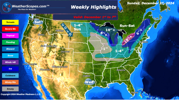
This week as we celebrate the holidays we will see some light lake effect snow bands in the Great Lakes and Northeast on Sunday. Accumulations look to be less than an inch. On Monday, a clipper will come through the Great Lakes into the Northeast late on Monday that will hang out until Wednesday. With the snow... Continue Reading →
Weekly Highlights December 15th to 21st
This week we will see rain, snow, ice, and the cold weather continue. Sunday, Western Michigan from Mount Pleasant to Kalamazoo will see some ice accumulations of around .10’’. Pennsylvania, from Altoona south to parts of West Virginia/ Virginia will also see some ice accumulations of around .10’’. Central Pennsylvania to parts of New York will see some snow around 1-3’’ into Monday. The Upper Plains... Continue Reading →
Weekly Highlights December 8th to 14th
This week while we start off with some warmer for December temps, that will change by mid-week. On Wednesday, a cold front will move into the Plains, Midwest, Northeast, and parts of the Southeast. Out ahead of the Cold front the Southeast will see some rain and gusty storms. On Sunday, parts of the Northeast and Maine will see some snow accumulations around 1-3’’. The Upper Plains/Great Lakes will see rain turn into snow throughout the day with some accumulations of around 1-4’’. The Great... Continue Reading →
Weekly Highlights December 1st to 7th
This week starts a new month with the same weather pattern we will continue to see. Cold, cold air coming down from Canada and impacting the Great Lakes, Midwest, and the Northeast. With the cold air coming down we will also see a few days of snow. On Sunday, a clipper will come down from the North into the Great Lakes and the Northeast with accumulations of 1-4’’. The same area will see another round of snow on Wednesday... Continue Reading →
