
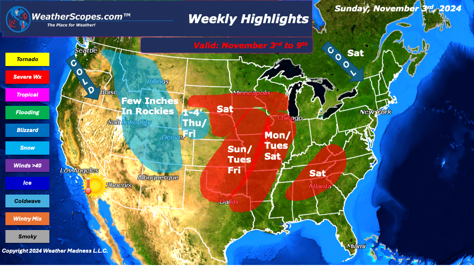
This week we still find ourselves in a weather pattern where there is a trough in the West, and a ridge in the East. Cold weather in the West , warmer weather in the East, especially the Southeast. The ENSO is staying neutral in regard to El Nino and La Nina, but the middle of the month look for the weather pattern to switch to a ridge in the West and a trough in the East. The Plains and Midwest this week will see storms develop almost every day, and the West will see snow throughout the week.
Sunday and Monday storms in the Texas/Oklahoma area will make their way NE into the Plains and Midwest. Tuesday storms will develop in Oklahoma and make their way NE into the Plains and Midwest. On Friday, a system will develop bringing warm air from the Gulf and Cold air from the north into the Plains and split off with snow to the West and storms to the East, in the Great Lakes and High Plains. Those storms will continue into Saturday. Also, on Saturday the Southeast and Tennessee Valley could see a round of severe weather. With these storms heavy rain and gusty winds will be the main concern. You can’t rule out a tornado developing with these storms, especially in Oklahoma and the Plains. These storms should also help with the drought that has been going on in these areas.
This week we also are watching snow to develop in the West. The Rockies will see multiple days of snow accumulation. The Rockies will get several inches of snow as cold air continues to make its way down from Canada. The NW portion of Nebraska could also see some accumulating snow towards the end of the week as a result of the storm developing on Friday.
The Plains, Midwest, and the East will see a nice week of weather other than the few days of potential storms. Warm weather continues to be hanging out in the South but has made its way up to the Midwest and parts of the East. For November, the temperature continues to be pleasant for the daytime highs. In some areas in the East chilly mornings with frost are now a common trend. Cooler weather will be moving into the Northeast on Saturday with temps barely getting to the 50’s.
We continue to watch the Tropics to see if anything will develop in the Caribbean over the next few days. The models still are showing something developing and the NHC is watching 2 areas for something to possible form. We will have to wait and see if anything will form.
By Matt K.
Weather Forecaster In-Training

Leave a comment