
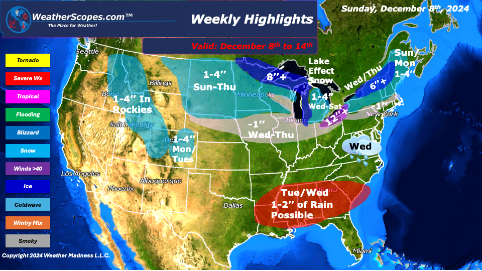
This week while we start off with some warmer for December temps, that will change by mid-week. On Wednesday, a cold front will move into the Plains, Midwest, Northeast, and parts of the Southeast. Out ahead of the Cold front the Southeast will see some rain and gusty storms.
On Sunday, parts of the Northeast and Maine will see some snow accumulations around 1-3’’. The Upper Plains/Great Lakes will see rain turn into snow throughout the day with some accumulations of around 1-4’’. The Great Lakes, UP of Michigan, and Northern Minnesota could see 6’’+ throughout the week with some snow and lake effect snow bands moving in. Parts of Wisconsin, Illinois, Iowa, and Indiana will see a dusting mid-week. The Cleveland/Buffalo area could see 12’’+ this week from a few days of snow and lake effect snow bands.
Wednesday, for the interior parts of the Northeast will see some accumulating snow 1-4’’, with areas closer to the I-95 corridor seeing mixed precipitation with mostly rain. The models are once again all over the place in agreement, but the GFS model has been steady with where the snow will likely be.
Tuesday and Wednesday, some rain and gusty storms will move through the Southeast with rain totals close to 2’’ in some areas. The Southeast has been very dry the last few months, so those areas will welcome the rain, but there could also be some localized flooding in some spots. Along with the rain, those storms could be severe and produce some hail and gusty thunderstorms.
The Rocky Mountains will see snow this week which is good for all the ski resorts. The Denver Metro area will see around a dusting to 3’’ Monday into Tuesday. Once again, the southern portion of the US will be where the warmer weather will be this week.
By Matt K.
Weather Forecaster In-Training

Leave a comment