
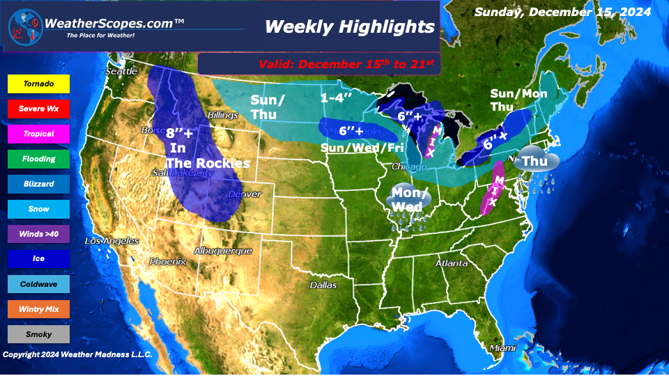
This week we will see rain, snow, ice, and the cold weather continue. Sunday, Western Michigan from Mount Pleasant to Kalamazoo will see some ice accumulations of around .10’’. Pennsylvania, from Altoona south to parts of West Virginia/ Virginia will also see some ice accumulations of around .10’’. Central Pennsylvania to parts of New York will see some snow around 1-3’’ into Monday. The Upper Plains to the Great Lakes will see snow as well with accumulations of a dusting to 3’’.
On Tuesday into Wednesday, a clipper will come through the Upper Plains and Midwest with snow accumulations of a dusting to 2’’, heavier amounts in Minnesota and Michigan.
Thursday, the models have been all over the place about if there is going to be a snowstorm on the East Coast or not. With the indices the way they are right now, and the NAO not being in a blocking pattern, that likely will not happen. For the interior parts of the Northeast expect some snow while areas south can expect some mixed precipitation along the I-80 corridor. Those snowfall totals will bearound 1-4’’. On Saturday, another clipper comes through the Great Lakes and Northeast, producing some snow and lake effect snow to the area. Accumulations will be around 1-4’’.
The Rockies will see a good amount of snow this week, with multiple days of snow. The Pacific NW continues to be wet as these storms come off the Pacific into the area one after the other. If you’re looking to escape the cold, the South and Southeast will continue to be sunny and warm.
By Matt K.
Weather Forecaster In-Training

Leave a comment