
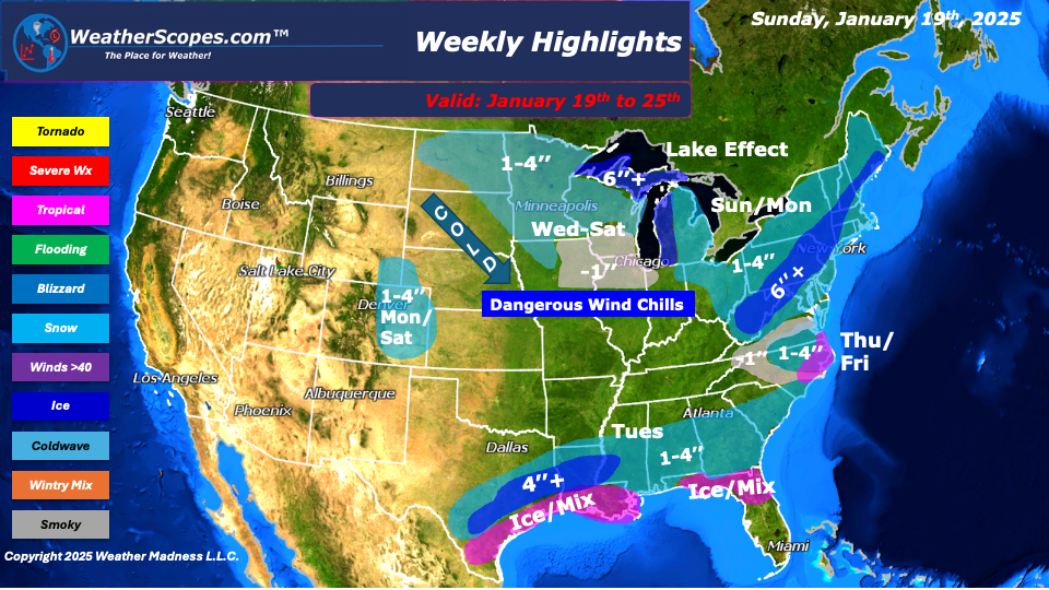
This week we start with an arctic winter storm making its way through the Great Lakes and Northeast today into tomorrow. The storm will bring very cold weather, wind, along with dangerous wind chills that are below zero through mid-week. Snow accumulations look to be around 1-4’’ with 4’’ + along the I-95 corridor. Blizzard like conditions will come with this storm and make for dangerous travel conditions. Monday and Thursday, the Denver metro area could see another round of snow. Accumulations look to be around 1-4’’.
On Tuesday, the South will see snow and ice. The Houston area to New Orleans and into the northern part of Florida will see ice and snow. An area where we don’t see this kind of weather happen will make for a historic storm. The Houston area could see 4’’+ and ice, and 1-4’’ around Houston and parts of Texas. New Orleans could see several inches of snow and ice as well, 4’’+. Northern Florida will see some mixed precipitation and about a 1’’ of snow. That storm will get in and get out by the end of the day on Tuesday.
Wednesday through Friday, the Northern Plains will see a few small clippers come through leaving a dusting to a coating of snow to some areas. Saturday, a clipper will come through the Northern Great Lakes and produce 1-4’’ of snow. Throughout the week the Great Lakes will see some lake effect snow. Accumulations look to be more than 4’’. Thursday night into Friday, the Carolinas could see some snow and ice. Accumulations look to be around 1-4’’, but this storm could intensify in the coming days and produce more snow than anticipated.
By Matt K.
Meteorologist In-Training

Leave a comment