
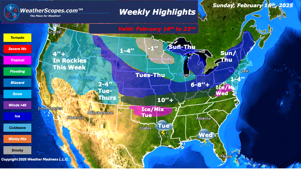
This week to start the Northeast will see some significant snow. Areas of NY to Vermont, New Hampshire, and Maine could see snow totals over 12’’ on Sunday, while areas south will see 1-4’’. On the backend areas of the Great Lakes will seesone snow as well. Accumulations 1-4’’. Along with the snow the Northeast will also deal with some ice and mixed precip associated with the storm, from central PA to the Boston area. Tuesday, will bring our next snow from the Rockies and the Denver area who will see 2-4’’, and will move into the Oklahoma/Texas area. Snow and ice will impact Oklahoma before the storm continues to the east. This storm will take its time getting to the Northeast on Thursday. As the storm moves through the Plains, Midwest, Tennessee and Ohio Valley, bringing some significant snowfall. Accumulations look to be 6-8’’ with 8’’ + not out of the question for some areas, from KC to the Ohio Valley. The Southeast will see rain and the chance for some severe weather on Tuesday and Wednesday from this storm. The Florida panhandle could see the best chance for heavy rain and severe weather.
Thursday, the snow will finally make its way to the Northeast and has the possibility to become a major snowstorm. I know the models are all over the place, but with the indices the way they are and the current weather pattern we are in, I would not be surprised to see areas in the Northeast seeing over 8’’. Upstate NY to Maine could see over 16’’ of snow by the end of the week from both snowstorms to come through.
The Rockies will see snow throughout the week with totals over 4’’. Temps will continue to be cold for most of the US, and even the Texas panhandle will see some temps this week in the 20’s.
By Matt K.
Meteorologist In-Training

Leave a comment