
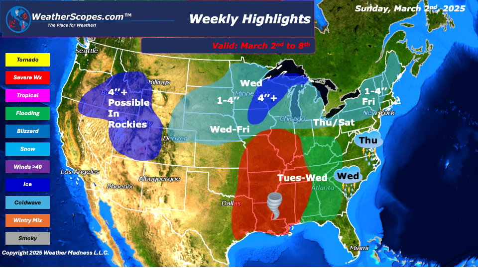
This week will bring some severe weather and snow. To start the week colder air will come down from Canada and will meet warmer moist air in the South, creating a battleground in the Mississippi Valley. On Tuesday, storms will develop in the Mississippi Valley with conditions favoring severe weather and a tornado outbreak. We will have to watch that area on Tuesday to see just how favorable conditions are. Along with the severe weather, we will also have to watch out for flooding in the Miss/Tenn Valley and the Mid-Atlantic states. Some areas could see over 1-2’’ of rain. The rain will continue to the east, making its way through the Ohio Valley and Northeast Wednesday into Thursday.
On the back-end of the storm on Wednesday, the Plains into the Great Lakes will see snow. Accumulations look to be 1-4’’ with areas in Northern WI, MI, and MN seeing more than 4’’ with blizzard like conditions possible. Some of those snow totals could be higher if we see the thunderstorms feed into the snow, as the moisture in the atmosphere will mix with the cold air. The snow will move through the Great Lakes Wednesday into Thursday and bring snow to the Northeast on Thursday night into Friday.
A clipper will come through the Plains into the Midwest on Friday and makes its way through parts of the Great Lakes and the Northeast on Friday night into Saturday. Total accumulations from the snow on Friday and the clipper Saturday look to be around 1-4’’ for the Great Lakes and Northeast. The Rockies will see some snow this week with some areas seeing over 4’’. The Denver area could see snow Monday night into Tuesday with accumulations of 1-4”.
By Matt K.
Meteorologist In-Training

Leave a comment