
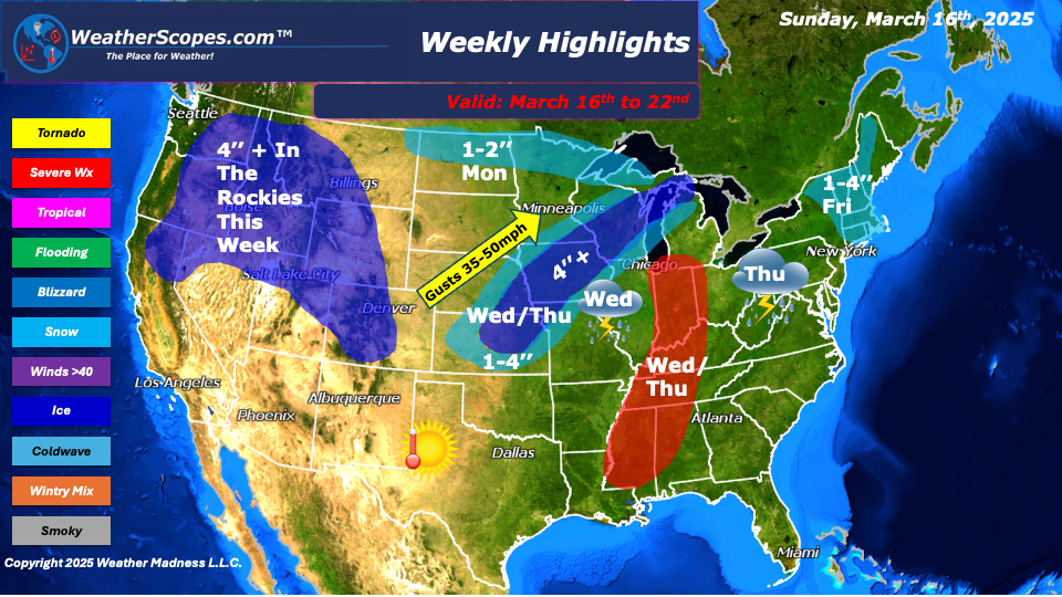
This week we switch gears from the multiple days of severe weather we saw last week to snow. We are in an interesting weather pattern where we see mild weather and then these shots of cold weather. On Monday, in the Northern Plains a clipper will come through and produce 1-2’’ of snow. Wednesday, we will see a storm develop in the Plains and make its way through parts of the Midwest and Great Lakes. Ahead of the storm you will see rain and some severe weather. On the backend some significant snow to areas in the Plains and Great lakes with accumulations of 1-4’’ and 4’’+ possible in parts of Wisconsin, Iowa, Nebraska, and Kansas. With the snow some gusty winds will accompany this system, where some areas could see blizzard like conditions. Also Wednesday into Thursday, some severe weather will break out ahead of this system in the Ohio Valley and will stretch down into the Tennessee Valley and into Gulf Coast States. These storms will produce gusty winds, hail, and if the conditions are right some tornadoes. As this system moves to the East on Thursday the Northeast could also see some rain and thunderstorms.
The Rockies will see some more snowfall this week as they did last week. The West has seen some stormy weather the past few weeks. Accumulations in The Rockies this week look to be over 4’’.
Friday, snow will develop in the Northeast on the backend of the rain/snow that went through the Midwest, as a cold front moves in. NY, Vermont, New Hampshire, and Maine, could see some accumulating snow. It’s still early to know whether this system will dip further south into the New England area. Accumulations look to be around 1-4’’ . Parts of Vermont and New Hampshire could see over 4’’.
By Matt K.
Meteorologist In-Training

Leave a comment