
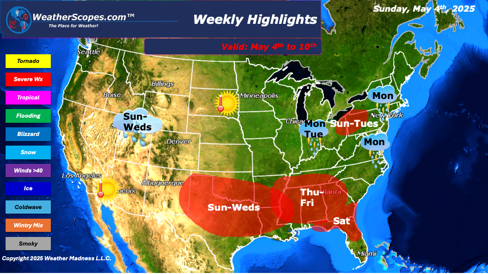
This week we are still in an omega blocking pattern that resembles the Greek letter, where two closed off lows separate from the jet-stream. Two low-pressure troughs of cool unsettled weather upstream (West) and downstream (East) and warm dry air in the middle (The Plains). We will be dealing with this pattern until mid-week, where the East and West will see daily chances for showers and thunderstorms, and cooler weather. The Plains into Texas will be where the warm weather will be until mid-week, when we kick this omega weather pattern. The very southern tip of the Southwest will also see warmer and dryer conditions. Sunday into Wednesday, the southern Plains into Texas will see daily occurrences of showers and thunderstorms. These storms will bring a daily chance of hail, gusty conditions, and tornadoes. The severe weather will then shift to the East in the lower Mississippi Valley into parts of the Southeast on Thursday into Saturday, where parts of Florida could see storms to close out the week. For the Northeast and Mid-Atlantic states from Sunday into Tuesday there will be daily showers and thunderstorms. Some of those storms could turn severe and bring some hail and gusty conditions, a tornado isn’t out of the question. Localized flooding will also be an issue this week for parts of the East and parts of the Southern Plains into Texas, where these areas could see several inches of rain on top of the rain they have already seen.
The Plains this week will be warm and dry from the Omega block and will see warm weather throughout the week. Later in the week around Wednesday into Thursday when we kick this blocking pattern milder weather will return to the most of the country. Parts of the Northeast will see cooler temps that will warm up by next weekend and dryer conditions.
By Matt K.
Meteorologist In-Training

Leave a comment