
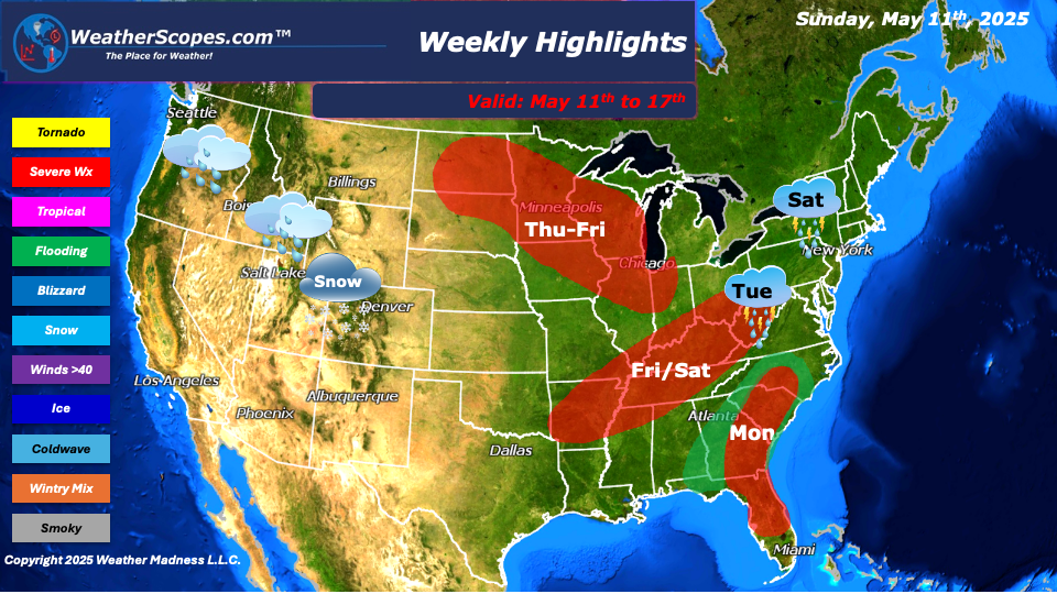
This week as we have gone away from the omega blocking pattern of last week and will see several days of severe weather, and wet and stormy weather in the east. On Sunday into Monday showers and thunderstorms will continue in the Southeast and parts of Florida. That area will have seen 2-6’’ of rain over the last few days. Localized flooding and the chance for some severe weather today and on Monday will be the main threat. On Tuesday, the rain will move into the Mid-Atlantic states and provide some showers and thunderstorms to the area. Wednesday, some showers and thunderstorms will continue in the Ohio Valley into parts of the Northeast. Some of those storms developing could be severe.
Thursday into Friday showers and thunderstorms will develop in the High Plains and move into parts of the Great Lakes and Midwest. Those storms look to be severe and could produce some hail, gusty winds, and a tornado is not out of the question. Friday into Saturday, the system in the Great Lakes moves into parts of the Northeast into the Ohio and Tennessee Valley, and more storms will develop in the Mississippi valley. There will be a chance for these storms to become severe. Hail, gusty winds, and tornadoes will all be in play with these storms as warmer temps and higher dew points will increase.
Tuesday into Thursday for parts of the Northwest and into the Rockies will see rain and snow in the higher elevations. Overall, most of the US will see some warmer temps this week apart from the Pacific NW who will see some cool and wet conditions throughout the week.
By Matt K.
Meteorologist In-Training

Leave a comment