
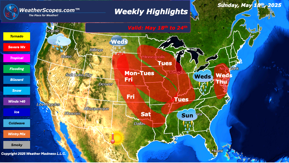
This week we continue to see severe, wet, and cooler weather in the East, while the Southwest and southern areas of Texas will see very warm temps. Sunday, showers and thunderstorms will develop in the Southeast, and parts of the Northeast. These don’t look to be severe and will just produce some rain. Monday, storms will develop in the Plains and portions of the Midwest. These storms look to be severe and produce hail, damaging winds, and tornadoes. Tuesday, the severe weather threat continues, as storms will form further east of the storms on Monday. Portions of the Midwest, Tennessee and Ohio Valley’s will deal with severe weather on Tuesday. Heavy rain, winds, hail, and tornadoes will all be in place with these storms. Wednesday, these storms will continue to the East into portions of the Northeast and Mid-Atlantic states as they produce showers and thunderstorms. Some of those could be severe and produce damaging winds and hail. This system will linger until around early Saturday as it continues to move East along the Northeast and producing rain Thursday to Saturday to areas along the coast. Friday into Saturday more storms will develop in the Plains down into Texas and the Mississippi Valley. More heavy rains, damaging winds, hail, and the chance for tornadoes are in play with these storms, and for most of this week with the severe weather. Dew points will be high especially on Tuesday and Friday into Saturday for portions of the Plains and the Ohio and Tennessee Valley’s.
The Pacific NW will continue to see cool and wet conditions this week, as they will see a good amount of rain this week. The Northern Rockies will see more rain and snow in the higher elevations this week, as well as some areas in North Dakota could see some flurries. We will also see cooler temps in the Northern Plains, Great Lakes, and the Northeast this week.
By Matt K.
Meteorologist In-Training

Leave a comment