
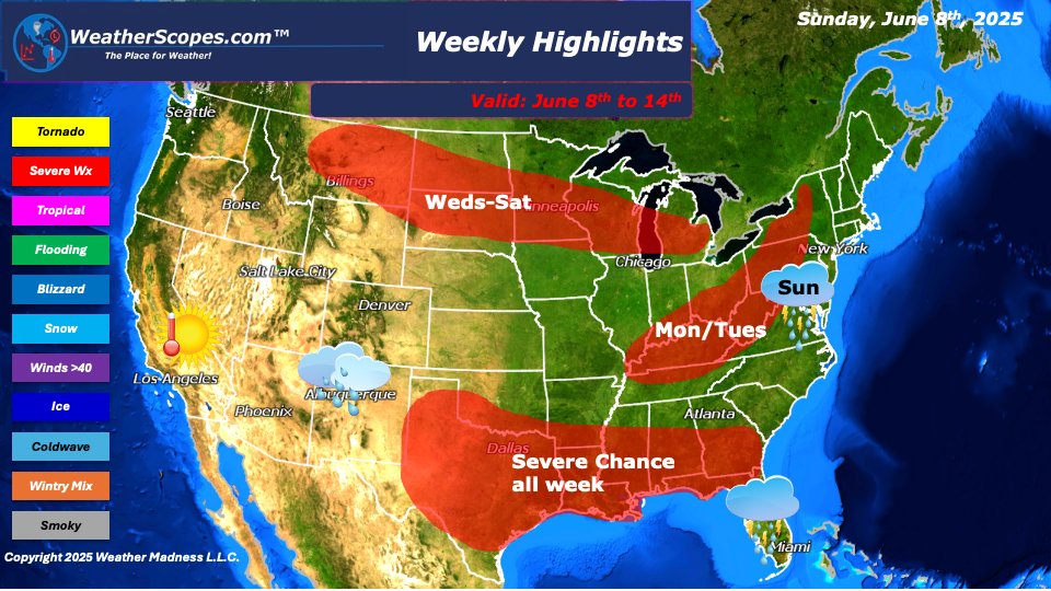
This week we will see a threat of severe weather daily in certain areas of the US, and we continue to deal with the smoke and haze from the Canadian wildfires. To start the week, we will see severe storms in the Mid-Atlantic states down to Florida. Heavy rains and winds will be the major threats, as well as some localized flooding. Sunday night storms will develop in the Southern Plains into Texas. With these storms gusty winds, hail, heavy rains, and tornadoes will all be in play. For the entire week from Western Texas through the South and into the Southeast, we could see a daily occurrence of storms develop. With the dew points high this week 60’s and 70’s we could see a chance for tornadoes daily across those areas. We will also have to watch out for flooding this week with how much rain portions of Texas through the Southeast will see. Monday into Tuesday storms will develop in the Tennessee Valley and makes its way to the East and parts of the Northeast. Some of those storms look to be severe and could produce some heavy rains and gusty conditions. Later in the week from Wednesday through Saturday, parts of Montana into the Northern Plains and parts of the Great Lakes could see a chance for storms daily. I would not be surprised if we saw some tornadoes associated with these storms mid-week in the Plains.
The Four Corner states will see daily showers this week, as they did last week. Florida also looks to see some daily showers and thunderstorms this week. Most of the US will see some milder temps this week. Later in the week the Northern Plains and Upper Great Lakes could see some cooler temps come in. Overall, this week looks to be stormy in some parts and warm in others. That is just the weather pattern we are currently in.
By Matt K.
Meteorologist In-Training

Leave a comment