
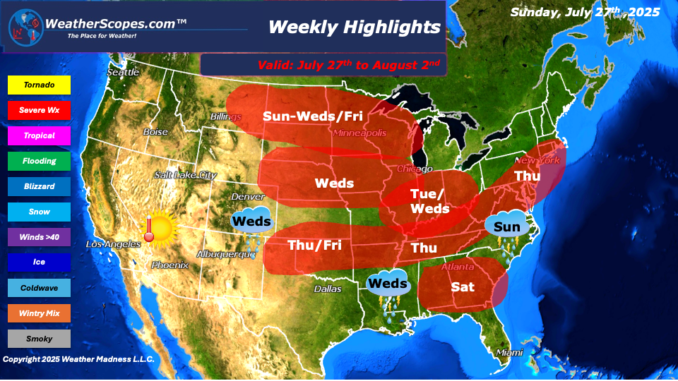
This week we will see hot and humid weather continue in the East, along with severe weather in the East and Northern Plains. All of that will change by the end of the week as we will see some nicer and more comfortable temps in the east while the hot weather is out in the west. To start the week on Sunday, storms will develop in the Mid-Atlantic states as well as parts of the Northeast. Those storms look to be gusty and could become severe. In the Northern Plains into the Upper Great Lakes from Sunday to Wednesday, severe weather looks to break out each day and could provide some tornadoes as well. The heat will be driving these storms to form in the Northern Plains, and with the high dew point temps once again this week, that area could see some tornadoes as well. Tuesday, storms look to fire up in the Ohio Valley and move into parts of the NE. Wednesday, more storms will break out in the Plains and move to the East into the Great Lakes and Ohio Valley. Tuesday and Wednesday across the Midwest and Ohio Valley we could see some tornadoes with Dew Point temps in the 70’s. Also on Wednesday, the Southeast could see some storms and some of those could become severe. Thursday looks to be a big severe weather day. Areas from the Northeast and Mid-Atlantic States through the Ohio and Tennessee Valley’s ending in Oklahoma, could see severe weather. Dew point temps will be high along these areas, so a few tornadoes would not be out of the question. Some heavy rains and winds will also be in play with these storms. The Ohio and Tennessee Valley’s and parts of Minnesota and Wisconsin could see some decent rainfall this week, which localized flooding could be an issue. Friday, more storms look to develop in the Northern Plains into the Upper Great Lakes. Also, on Friday some storms look to develop in the Southern Plains.
Friday, the weather pattern looks to switch as a high-pressure system will bring a cooler air mass to the eastern part of the country, while the west will see hot weather. On Saturday the Southeast could see some severe weather develop. The tropics remain uneventful. In the next week or so we will have to keep an eye out on the East Coast for something to possible develop. As these high-pressure systems come down from the north they trap or suppress the cold fronts. When warm moist air from the Gulf meet the fronts, they can create a hybrid type subtropical system to form off the coast.
By Matt K.
Meteorologist In-Training

Leave a comment