
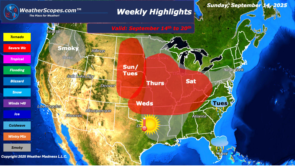
This week’s weather is shaping up to be a dynamic mix of smoke-filled skies, summer like heat, and an extended stretch of stormy conditions. Smoke from the wildfires burning across the Pacific Northwest and Western Canada is making its way across much of the United States this week. This widespread smoke plume is affecting the Northwest, Plains, Midwest, Southeast, and parts of the Northeast. Many areas can expect hazy skies, muted sunshine, and reduced air quality, particularly during the morning and evening hours. Sensitive groups, including those with respiratory conditions, should monitor local air quality indexes and limit outdoor activity if needed.
Meanwhile, a persistent ridge of high pressure remains locked over the Plains and Midwest, keeping temperatures well above average for mid-September. Highs are expected to climb into the upper 80s and low to mid-90s across many areas. This ridge is also helping to trap heat and humidity at the surface, creating unstable conditions that will support rounds of thunderstorms — some of which could turn severe.
The severe weather threat begins on Sunday and is expected to stretch through Saturday, with the potential for daily rounds of storms across the Plains, Midwest, and Ohio Valley. Monday appears to be the one exception, with a temporary break from widespread severe weather. However, the rest of the week looks active, with the combination of daytime heating and abundant moisture fueling the risk for damaging winds, hail, and possibly isolated tornadoes — especially during the afternoon and evening hours.
Further south, Florida will experience a daily chance of thunderstorms beginning midweek, largely driven by tropical moisture and daytime instability.The Carolinas will see a wetter pattern develop starting Tuesday and lasting through Thursday, with multiple rounds of showers and storms.
In the tropics, things are relatively quiet for now. This week, the Atlantic basin doesn’t look particularly impressive in terms of tropical development. However, the National Hurricane Center (NHC) is monitoring a tropical wave just off the coast of Africa. While there’s currently low potential for development in the next few days, it’s something to keep an eye on as it tracks westward into more favorable conditions.
By Matt K.
Meteorologist In-Training

Leave a comment