
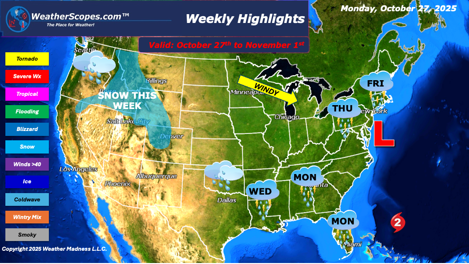
A rather active weather pattern is shaping up across the country this week. Showers will persist across the Pacific Northwest, bringing periods of rain and cooler temperatures to coastal and inland areas. Higher elevations could see a mix of rain and wet snow as moisture continues to move in from the Pacific. Meanwhile, the Rockies will also experience snowfall in the higher elevations, signaling that winter is beginning to make its early presence felt in the region.
Across the Southeast, showers will develop Monday into Tuesday, with some heavier downpours leading to localized flooding in low-lying areas. By Tuesday into Wednesday, a developing low-pressure system will move through the Plains and into the Mississippi Valley, bringing scattered showers and thunderstorms. This same system will continue its trek into the Northeast later in the week, setting the stage for a more significant coastal storm heading into the weekend.
By Thursday into Friday, that coastal storm will impact the Northeast, delivering periods of heavy rain and strong winds along the coast. Behind the system, gusty conditions are expected as cooler air filters in, creating a blustery end to the week for much of the region. Higher elevations in the Northeast could also see some snow this week as well.
Meanwhile, in the tropics, Hurricane Melissa continues to intensify in the Caribbean and is expected to remain a Category 5 by landfall in Jamaica on Tuesday. The storm will bring catastrophic damage to Jamaica, Haiti, and the eastern portion of Cuba as it moves through before reemerging into the Atlantic mid-week. At this time, there remains no immediate threat to the U.S. mainland, though the system will be closely monitored as it moves northward.
By Matt K.
Meteorologist-In-Training

Leave a comment