
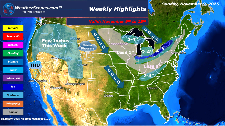
This week’s weather pattern is shaping up to be quite active across much of the country, with multiple systems bringing a mix of snow, rain, and even the potential for severe weather. A lake-effect system will move into the Great Lakes early in the week, bringing light to moderate snow across parts of the region. Many locations could see a coating to around 2 inches, while areas closer to the Great Lakes may pick up over 4 inches due to enhanced lake-effect bands. Gusty winds of 25-35mph will accompany this system, making for reduced visibility and some slick travel conditions. The way this storm is tracking currently its taking shape for some dangerous conditions over the next 24 hours. Alongside the snow, a blast of colder air will slide down from Canada, spreading across the Plains, Midwest, and Northeast. This will bring a brief stretch of winter-like temperatures to start the week before temp’s warm-up slightly midweek. The Northeast and parts of the Tennessee Valley will also see chances for snow, with a fast-moving clipper system arriving Sunday into Tuesday. A coating to around 2 to 3 inches is possible, particularly in higher elevations and areas north of major cities.
Farther west, the Rockies will continue to see periods of snow this week, adding to early-season accumulations. Meanwhile, the Pacific Northwest and parts of the West Coast will deal with unsettled weather, as showers and a few thunderstorms develop. Thursday looks particularly active for the Sacramento Valley, where some stronger storms could move through. Southern California may also see thunderstorms, and a few could become severe if conditions align.
As we look toward the end of the week, another system will bring snow into the Northern Plains Friday into Saturday, potentially producing a few inches of accumulation. Then, attention turns to the central U.S., where Saturday into Sunday could feature developing severe weather across parts of the Plains and Mississippi Valley. It’s still several days out, but this system bears watching to see how far north the storms may reach or if they remain confined farther south.
By Matt K.
Meteorologist In-Training

Leave a comment