
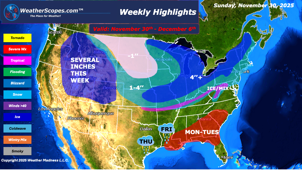
As winter ramps up, this week’s forecast brings a mix of snow, cold, and even severe storms across large swaths of the U.S. — from the Rockies and Plains to the Midwest, Great Lakes, and Northeast. On Sunday, snow arrives for the Northeast to kick off the week, with accumulations expected to reach 1–4″. Meanwhile, in the Southeast on Monday into Tuesday, conditions shift as severe storms return, bringing rain, wind, and the potential for some localized flooding to the area. As we move into Tuesday, the forecast turns complicated for parts of Arkansas, the Ohio Valley, and West Virginia. These regions could see a mix of precipitation — including snow, sleet, or ice — creating the possibility of a troublesome ice event. Travel and road conditions may become hazardous as temperatures hover around freezing.
By midweek and extending into Friday through Saturday, the snow again becomes more widespread. A swath of snow that begins in the Plains and is expected to push through the Midwest and into the Northeast. Many interior areas of the Northeast, along with large portions of the Midwest and Great Lakes region, could pick up a coating to more than 4″ — with some interior spots getting 6″ or more over the week. on Thursday and Friday, showers and thunderstorms are expected to impact Texas and extend into the lower Mississippi Valley, bringing periods of heavy rain. The Rockies will see several inches of snow this week and the Denver metro area could also see a dusting of snow as well.
If you live in or plan to travel through any of these regions, now is a good week to stay alert. Snow, ice, and storms could mean slick roads, and tricky travel conditions. On the bright side for winter lovers, this forecast also signals that the snow season is well underway.
By Matt K.
Meteorologist In-Training

Leave a comment