
This week’s weather pattern will bring a mix of milder temperatures, winter systems, and the potential for severe weather across different parts of the country.
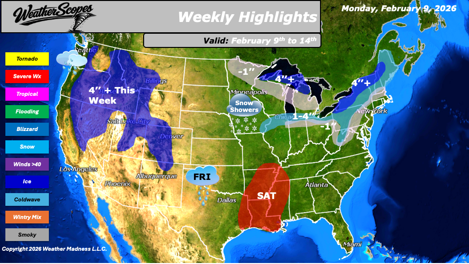
Some milder weather is expected across the Plains into the Midwest this week, with temperatures climbing above the freezing mark. While it will not feel warm by any stretch, this represents a noticeable change compared to recent conditions. Farther east, the Northeast will also see a moderation in temperatures. After enduring freezing and even below-zero conditions, temperatures are expected to settle into the 20s for much of the week, offering some relief from the recent extreme cold. A clipper system will track through the Upper Great Lakes into the Northeast on Tuesday and linger into Thursday. This system will bring light to moderate snowfall, with accumulations ranging from a coating to over 4 inches in more interior portions of the Northeast. Another clipper system is forecast to move through parts of the Plains into the Midwest on Thursday. Snowfall with this system should generally be lighter, with a coating to around 1 inch possible in many areas.
Attention then turns to the Southern Plains as showers and some possible thunderstorms develop on Friday, signaling the start of a more active and potentially stormy weekend. By Saturday, storms are expected to develop across eastern Texas and move through the Mississippi Valley into portions of the Southeast. With dew points rising into the 50s and 60s, conditions may become favorable for severe storms and gusty winds across the South and Southeast from Saturday into Sunday.
On the northern side of this storm system, colder air will support snow across parts of the Midwest into the Ohio Valley from Saturday into Sunday. Portions of the Northeast will also see snow on Sunday, with the potential for snowfall lingering into Monday. Out west, unsettled weather continues, with stormy conditions expected in the Pacific Northwest and snow across much of the Rockies and the Sierra Nevada.
In addition to the active weather pattern, river conditions will need to be monitored closely across the eastern portion of the country. Many rivers and river basins have been frozen, and as temperatures rise and ice begins to thaw, there is an increasing risk for ice jams and localized flooding.
By Matt K.
Forecaster

Leave a comment