
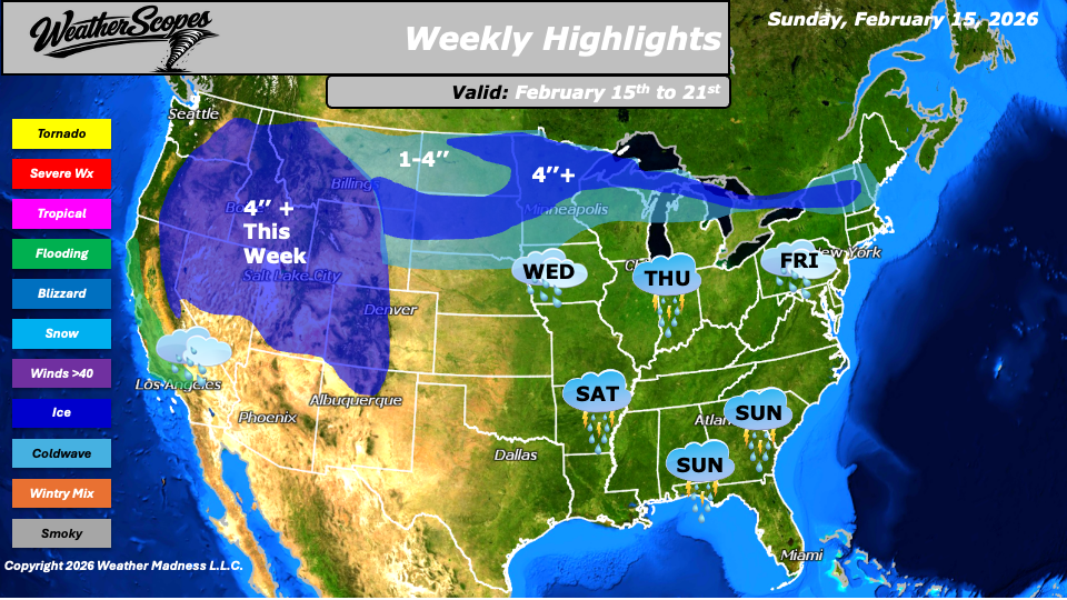
This week’s weather pattern across the United States will feature a dynamic mix of severe storms, heavy rain, accumulating snow, and a return to colder air by next weekend. Multiple systems moving from west to east will bring changing conditions to many regions, with some areas experiencing more active weather than others.
To start, some showers and thunderstorms are already moving through the Southeast and into parts of Florida, producing some severe weather. Gusty winds, heavy rainfall, and the potential for isolated tornadoes will remain concerns as this system tracks eastward. Residents across the Southeast should stay alert for rapidly changing conditions, especially during the strongest storms. Farther north, a surprise round of snow is expected in parts of Eastern Pennsylvania and into New Jersey, where a coating to 2 inches is possible Sunday night into Monday. While this is not a major winter event, it may lead to slick spots during the morning commute.
Out west, rain will persist throughout the week in California, where there is a potential for flooding. Repeated rounds of precipitation may lead to rising rivers, localized flooding, and hazardous travel in flood-prone areas. These storms will also produce snow in the higher elevations of the Rockies and the Sierra Nevada, where 4 inches or more is possible this week. Mountain travel could become difficult at times due to accumulating snow and reduced visibility.
Midweek, on Wednesday, and again Friday into Saturday, snow and rain will move through the Northern Plains, Northern Great Lakes, and into parts of the interior Northeast. While temperatures will be mild across much of the Plains and Midwest, keeping precipitation primarily in the form of rain, areas farther north will see rain transition into mixed precipitation and snow. Accumulations of 1 to 4 inches look likely in many locations, with 4 inches or more possible in the Northern Great Lakes, some areas of the Northern Plains, and parts of the Northeast. On Thursday, the Plains into the Great Lakes will see more of the same, with another round of snow and rain moving through the region. By Saturday, attention shifts back to the central United States, where a chance for showers and thunderstorms will develop across the Mississippi Valley and Tennessee Valley. Some of these storms could become severe, bringing the potential for damaging winds and heavy rainfall. Meanwhile, after a stretch of milder weather in the eastern United States, colder air is expected to return next weekend, with temperatures dropping back into the 20s and 30s across parts of the East.
By Matt K.
Forecaster

Leave a comment