
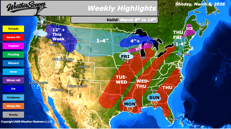
The week begins with unsettled conditions across the Southeast on Sunday, where showers and thunderstorms are expected to develop and move through the region, and again on Monday in the Lower Mississippi Valley. Attention then turns to a more significant storm system developing Tuesday into Wednesday. Severe weather is expected to return from the Upper Great Lakes southward to Texas. As the system evolves, it will gradually shift east through midweek. From Tuesday through Thursday, much of the eastern half of the United States will face the potential for severe weather, including strong thunderstorms capable of producing damaging winds, heavy rainfall, hail, and tornadoes. By Thursday, this system is expected to reach the Mid-Atlantic states. North of the main storm track, colder air will push southward beginning Tuesday into Wednesday. This setup will create a battleground between warm and cold air masses, leading to a mix of snow and ice across Wisconsin and Michigan. Parts of the Northern Plains and the Upper Great Lakes are likely to see snowfall totals ranging from 1 to 4 inches.
As the system continues east, portions of the Northeast could see snow on Thursday, with totals generally ranging from 1 to 4 inches. Northern Maine may also experience icy conditions during this time. Another weather system is forecast to move through the Northern Plains into the Great Lakes from Thursday into Friday. This system will once again produce rain to the south and snow to the north. Central to northern Wisconsin and central to northern Michigan could see more than 4 inches of accumulating snow this week. As this system progresses eastward, interior sections of the Northeast will also see snow.
By Saturday, additional accumulating snow is expected to move across the Plains with totals around 1 to 4 inches. A fast-moving clipper will also track from the Upper Great Lakes into the Northeast, bringing another round of snow, with totals of 1-4’’ possible this week in the Northeast. Meanwhile, conditions across much of the western United States will remain relatively calm with sunshine and generally pleasant weather. However, the Pacific Northwest will continue to experience an active pattern. Multiple rounds of rain and mountain snow are expected, particularly across the northern Rockies and the Cascades, where some higher elevations could see more than a foot of snow by the end of the week.
By Matt K.
Forecaster

Leave a comment