
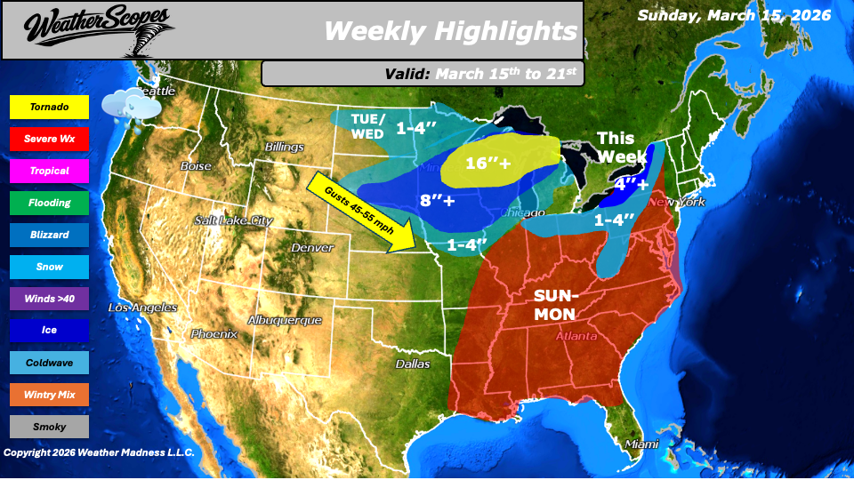
Sunday will bring a significant winter storm to parts of the Upper Midwest and Great Lakes, with heavy snow and powerful winds creating extremely dangerous travel conditions. Central to Northern Wisconsin, the Upper Peninsula of Michigan, and Northern Michigan will experience gusty conditions creating blizzard-like conditions throughout the day. Most areas are expected to see snowfall totals of 8”+, while some locations could receive well over 16” and closer to over 24”. Wind gusts of 45-55 mph will lead to blowing and drifting snow, significantly reducing visibility and making travel dangerous at times. South of the winter storm, a severe weather outbreak is expected to develop across the Midwest, stretching southward into the Lower Mississippi Valley and Tennessee Valley. Thunderstorms forming ahead of an advancing cold front will have the potential to produce all hazards, including damaging winds, large hail, and tornadoes. Areas closer to the Ohio and Tennessee Valleys appear to have the greatest potential for tornado development. This same cold front will push through the Midwest late Sunday into Monday, setting the stage for the colder air and snow that will spread into the region afterward.
Monday, as the severe weather threat shifts eastward, snowfall on the backside of the system will expand across portions of the Midwest, including areas south of Sunday’s blizzard zone. Snow accumulations of 1 to 4 inches are expected, with a few locations exceeding 4 inches. Meanwhile, the severe weather threat will move into the Ohio Valley, the Northeast, the Mid-Atlantic, and portions of the Southeast. All hazards will be possible with these storms as the system continues to progress eastward.
Tuesday, colder air wrapping around the departing storm system will allow snow to develop across parts of the Northeast and the Appalachian region, with accumulations generally in the 1 to 4 inch range. Later Tuesday into Wednesday, a fast-moving clipper will track from the Upper Plains through the Great Lakes and into parts of the Midwest, adding additional light snowfall to areas that will already be digging out from earlier in the week. Another clipper is expected Thursday into Friday, bringing additional snow to the Great Lakes and portions of the Northeast. Some areas in the interior Northeast could see weekly snowfall totals exceed 4 inches. Ahead of this system, parts of Wisconsin, Illinois, and northwest Indiana may see early morning showers and thunderstorms. Behind the storm system, colder temperatures will settle in across the Northern Plains, Great Lakes, and Northeast for much of the week. While the cold will dominate the forecast through several days, there are signs that milder temperatures could begin to return to these regions later in the week and into the upcoming weekend. Across the Pacific Northwest, unsettled weather will persist throughout the week with periods of rain and mountain snow. Higher elevations in the Northern Rockies will see accumulating snowfall at times as several disturbances move through the region.
By Matt K.
Forecaster

Leave a comment