
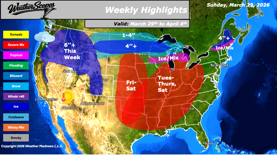
This week we will see a gradual warming trend will take hold for much of the country, however, colder conditions will persist across the northern portions of the Plains, Great Lakes, and Northeast, where winter-like weather is not quite ready to release its grip. Tuesday attention turns to a developing severe weather pattern and continuing through Thursday. Storms are expected to form from the Midwest down into parts of Texas before shifting eastward into the Ohio and Tennessee Valleys and eventually the Southeast. The environment will be primed for strong to severe storms, with dew point temperatures climbing into the 60s as warm, moist air surges northward from the Gulf. This setup supports the potential for all severe weather hazards, including damaging winds, large hail, and tornadoes. In addition to the severe threat, heavy rainfall may lead to flooding concerns, particularly across the Ohio and Tennessee Valleys.
Midweek will also bring a return of wintry weather to parts of the Upper Great Lakes and northern New England. From Wednesday into Thursday, a mix of precipitation is expected across areas including Vermont, New Hampshire, and Maine. By Thursday, colder air wrapping into the system will allow for snowfall across portions of the Great Lakes, with accumulations generally ranging from 1 to 4 inches, and localized amounts exceeding 4 inches. Another system will track through the Northern Plains Friday into Saturday, pushing into the Great Lakes and delivering another round of snowfall. Similar accumulation totals of 1 to 4 inches are expected, with some areas potentially exceeding 4 inches. At the same time, the Plains will once again become a focus for severe weather development Friday into Saturday, with storms advancing into the Midwest and Mississippi Valley.
Out west, an active pattern will persist throughout the week. The Pacific NW will see continued periods of rain, while the higher elevations of the Northern Rockies and Sierra’s will pick up some significant snowfall. Totals in these regions will exceed 6’’ this week, contributing to an already substantial snowpack.
By Matt K.
Forecaster

Leave a comment