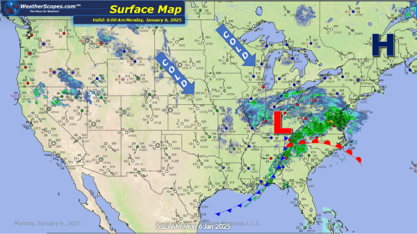
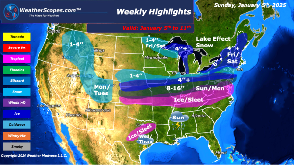
The snowstorm that mades its way through the Plains and Midwest yesterday now hitting the Northeast today. Heavy snow in the DC area with accumulations of 8-16''. Ice and sleet in the Tennessee Valley through Virginia and North Carolina. Moderate snow in the Ohio Valley into Pennsylvania and NY, with accumulations of 1-4''. Lake effect... Continue Reading →
Weekly Highlights January 5th to 11th
This week a major snowstorm is well under way. From KC to DC and in between, should see significant amounts of snow and blizzard like conditions. The snowstorm will make its way through the area on Sunday and Monday. Snow accumulations range from a dusting to 16’’ + from areas in Nebraska through the Ohio/Tennessee Valley and into the Nations Capital. The DC area could see over... Continue Reading →
Daily Maps Sunday January 5th, 2025
Today the first big snowstorm of the season will hit the Plains, Midwest, Tennessee Valley and into the Northeast. Heavy winds are driving this storm to the East, and bringing ice and heavy snow to some areas. Snow rates will be 1-3'' an hr and some areas in the middle of this storm could see... Continue Reading →
Daily Maps Saturday January 4th, 2025
Big winter storm coming into the Plains today and tonight that will move through the Midwest, and into the Northeast over the next few days. Snow accumulations ranging from a dusting to a few inches to some 20'' possible. Ice will also be associated with this storm and will make for some dangerous travel in... Continue Reading →
