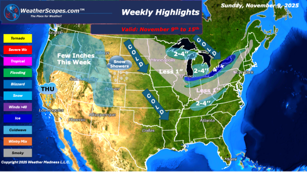
This week’s weather pattern is shaping up to be quite active across much of the country, with multiple systems bringing a mix of snow, rain, and even the potential for severe weather. A lake-effect system will move into the Great Lakes early in the week, bringing light to moderate snow across parts of the region.... Continue Reading →
Daily Maps Sunday November 9th, 2025
Today into tomorrow a clipper coming down from Canada will bring snow and windy conditions to the Great Lakes, Northeast, and parts of the Tennessee Valley. Most areas will see anywhere from a coating to 2'' while areas closer to the Great Lakes could see over 4'' of snow. The area will also see some... Continue Reading →
Daily Maps Saturday November 8th, 2025
Today a cold front coming into the Plains and Midwest will bring rain/snow showers to the area, as well as colder temps. This system will move to the east over the next few days bringing the first snowfall to many areas in the Midwest, Great Lakes, and Northeast. Some areas in the Mid-Atlantic states could... Continue Reading →
Daily Maps Friday November 7th, 2025
Today the Pacific NW will see more showers and thunderstorms, with the higher elevations of the Rockies seeing some snow. Showers and thunderstorms will break out across the Midwest, Upper Great Lakes, and Northeast. There is a chance for some of these storms to be severe in areas in the Tennessee Valley. Behind these storms... Continue Reading →
