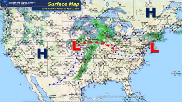
This morning, light snow is occurring across the Plains, with accumulations ranging from a light coating up to 1 inch. Lake-effect snow will once again impact the Great Lakes region today, with the heaviest accumulations expected in the Upper Peninsula of Michigan, the Buffalo area, and southeastern Wisconsin into the Chicago metro area. Most locations... Continue Reading →
Daily Maps Thursday January 29th, 2026
This morning, a clipper system is moving through the Plains, producing a light coating of snow. Lake-effect snow continues to impact the Great Lakes region today, with accumulations of 4 inches or more in areas closest to the lakes. Arctic cold remains entrenched across the Plains, Great Lakes, and Northeast, with temperatures well below zero... Continue Reading →
Daily Maps Wednesday January 28th, 2026
This morning, a clipper system is moving through the Great Lakes into the Northeast, bringing continued lake-effect snow to the region. Snow accumulations are expected to be light for most areas, generally a coating, while portions of the Upper Peninsula and western Michigan could receive more than 3 inches. The Buffalo and Syracuse areas may... Continue Reading →
Daily Maps Tuesday January 27th, 2026
This morning, we are already seeing some lake-effect snow showers across the Great Lakes with some blowing snow making conditions blustery. The snow will last into Wednesday with areas seeing accumulations of a coating to 4''+ the closer you are to the Lakes. Arctic cold weather still impacting the Plains into the Great Lakes and... Continue Reading →
