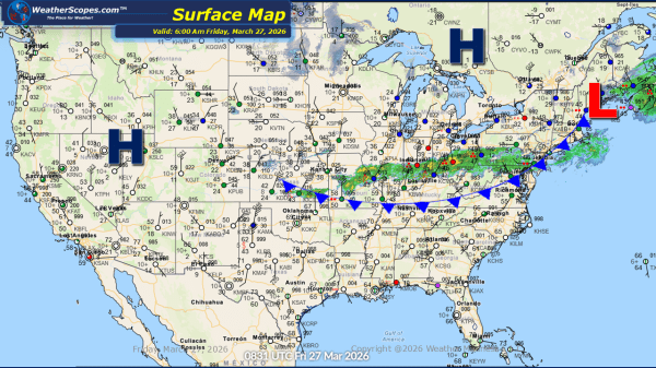
This morning, we are seeing showers from the Mid-Atlantic states all the way back into the Mississippi Valley. Those showers will track to the SE throughout the day, where we could see isolated thunderstorms develop in the Tennessee Valley to the Mid-Atlantic. After yesterday's severe weather came through the Midwest, Ohio Valley and into parts... Continue Reading →
Daily Maps Thursday March 26th, 2026
This morning, we are seeing showers come across the Great Lakes and some pop up showers through West Virginia. These early precipitation patterns are setting the stage for a more impactful weather scenario later in the day. As we move into the afternoon and evening hours, a cold front advancing through the Midwest will create... Continue Reading →
Daily Maps Tuesday March 24th, 2026
This morning, light snow showers have been moving through the northern portion of Michigan and extending into parts of Canada. While much of this precipitation is not reaching the ground, a light dusting of snow remains possible in some areas. Out west, the Pacific Northwest is experiencing widespread showers accompanied by gusty winds. This precipitation... Continue Reading →
Daily Maps Monday March 23rd, 2026
This morning, showers are exiting the Northeast following a round of storms that produced 95 reports of hail and damaging winds across the region. On the back side of this system, parts of New England, especially northward into Maine, may see some light snow, with accumulations generally limited to a coating at most. Farther south,... Continue Reading →
