Weekly Highlights March 22nd to 28th

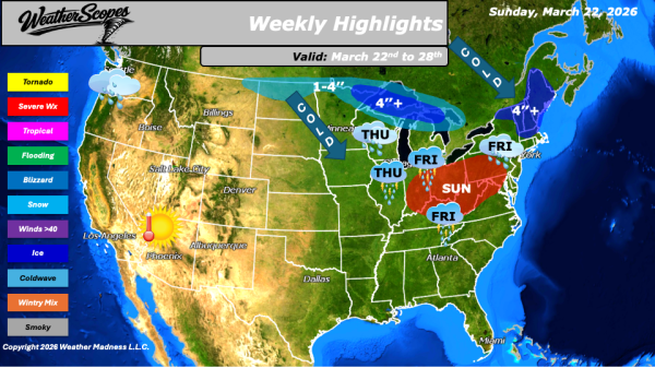
This week’s weather pattern across the United States will feature an active mix of severe storms, temperature swings, and recurring snow systems, particularly across the northern tier. On Sunday, severe thunderstorms are expected to develop across the Northeast, extending through the Ohio Valley and into the Mid-Atlantic. Some of these storms may become gusty and... Continue Reading →

Daily Maps Friday March 20th, 2026

This morning, we are seeing a mix of rain and snow moving through the Northeast. Areas across northern Vermont, New Hampshire, and Maine are expected to pick up accumulating snowfall in the range of 1 to 4 inches, while locations farther south and into the Mid-Atlantic are experiencing mainly rain. Out west, rain continues across... Continue Reading →

Daily Maps Wednesday March 18th, 2026

This morning, we are seeing snow showers come through the Midwest and Upper Great Lakes. Light accumulations with this clipper are expected, generally ranging from a coating to around one inch. Cold weather is still impacting the Plains through the Midwest and into the Northeast, maintaining a firm grip across much of the region. However,... Continue Reading →

Daily Maps Tuesday March 17th, 2026

This morning, we are seeing some light snow showers across the Upper Great Lakes, into parts of the Ohio Valley and into the Northeast. Accumulations look to be light with a coating to 1–2''. Attention also turns to a clipper moving through the Northern Plains into the Plains today, which is expected to advance into... Continue Reading →

Website Powered by WordPress.com.

Up ↑